Your Highways Network At Your Finger Tips
The SmartVision platform combines AI-powered image analysis, geospatial mapping and inspection management into a single, intuitive platform.
Teams can visualise inspection coverage, monitor defect trends, identify repair clusters and generate PAS 2161-aligned reports from a single system.
From first capture to confirmed fix, the SmartVision platform provides a seamless workflow that turns raw road images into intelligent infrastructure management.
.png)

DfT PAS Road Scoring
All roads are conditioned based on the DfT PAS scoring criteria. Simply drive a road and within minutes see the results.
The SmartVision platform allows you to understand which roads have not been surveyed and allows you to understand which road inspections are required.
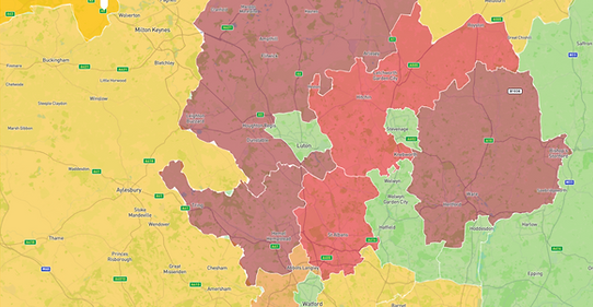
Area Summary
Look at road health by ward, area or district. Understand which areas need to be inspected and which areas need the most amount of attention.

Live Feed
See defects as they are fed into the system. The technology provides a recommend maintenance plan based on your inspection criteira.
All your highways inspector needs to do is confirm and the defect will be sent to the works flow manager for fixing.
Problem Areas
Our algorithm groups defects based on size and proximity, allowing highway teams to swiftly identify clusters of nearby defects. This means they can address multiple issues in a single day instead of just reactive pothole repairs one by one.

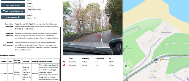
Defect Analysis
All defects are automatically analysed with the size, risk, priotioty and recommended maintenance plan.
The output can be completely tailored to the revelavnt highways local authority, so that every output meets your requirements.